Facebook
Instagram
YouTube
Our Work
Wetland Protection
Take Action for Michigan’s Wetlands
Vape Recycling
Mining Action
Copperwood
Tilden
Native Plant Garden
Spaceport Threat
Get Involved
Events and Volunteer Opportunities
Subscribe to our Mailing List
About
Our Story
Our Team
News & Updates
Job Opportunities
Subscribe to our Mailing List
Contact
Page Not Found
Sorry, the page you requested could not be found.
Categories
Articles
(11)
News
(55)
Recent Posts
Wetland Buffers: Protecting Michigan’s Wetlands Beyond Their Boundaries
June 30, 2026
Introduction Wetlands provide essential ecosystem services, including water filtration,
[…]
Do You Have a Wetland on Your Property? A Landowner’s Guide to Wetland Identification
June 2, 2026
Wetlands are among Michigan’s most valuable ecosystems, providing wildlife habitat, improving
[…]
A Toxic Legacy in the Making
October 1, 2025
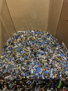
The environmental Toll of Disposable Vapes By James Brook Abstract: The rise in disposable
[…]
Our Work
Wetland Protection
Take Action for Michigan’s Wetlands
Vape Recycling
Mining Action
Copperwood
Tilden
Native Plant Garden
Spaceport Threat
Get Involved
Events and Volunteer Opportunities
Subscribe to our Mailing List
About
Our Story
Our Team
News & Updates
Job Opportunities
Subscribe to our Mailing List
Contact
 A Toxic Legacy in the Making